Advanced Certification In 3D Mapping and Surveying
Get hands-on How to Create 3D Models
2 Days of Training
How to Create 3D Models
How to Analysing or Evaluation Data
Curriculum designed such that
you make the most of it
Introduction to 3D mapping & surveying
Indroduction
- Introduction to 3D mapping & surveying
- Survey history
- Triangulation
- Terminologies
- Co-ordinate systems
- Control survey
3D Drone surveying
- Current Drone surveys
- 3D mapping
- SLAM: Simultaneous localization & mapping1
- Acoustic mapping
- Alternative sensors
Geo spatial infrastructure
- Define GIS
- Principal applications of GIS
- Functions of GIS
- Components of GIS
- GIS data models
3D mapper softwares
- About 3D mapping softwares
- 3D mapper, principles & Innovation
- Market application examples
- cloud services
- 3D process
Practical sessions on 3D mapping process
- capture images using software
- uploading images into mapper
- 3D mapping processing
- output
- practical session
Practical session
Practical session on how to analyze 3D mapping data
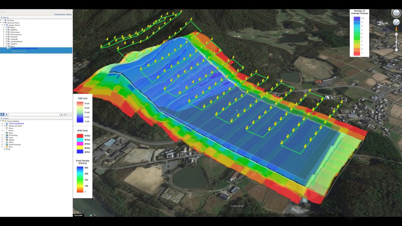
- Layers of a 3D Mapping
- Analysing Evaluation Data
- Performing Volumetric Calculations
- Cut, Fill, and Volumetric Measurement Calculation
- Lowest Point and Best Fit Base Planes Adjusting Histogram to Change Elevation Values
Using ground control points
- Creating GCPs
- Placing GCPs
- Utilizing the GCP Checklist Submitting GCPs in 3D mapping softwares
Exporting your data
- Export Options in 3D mapping softwares
- Static Layer Export Procedures
- Custom Layer Export Procedures
- Sharing Your Map
Find A Training Center Near You
Why Should You Do This Course?
- Get trained from expert instructors
- Perfect course for people who want to gain in depth knowledge in 3D mapping & surveying
- Explore the opportunities in Drone market
- Get hands on experience of 3D mapping & surveying
- To understand the drone based surveying
Course fee: ₹ 15222.0 (incl. GST)
Frequently Asked Questions
This course is designed for drone pilots looking to expand their skillset to include surveying, mapping, or modeling. It will lead you through the basics of drone surveying from flight planning to data capture.
Pre-qualification required-Drone pilot training in Multirotor
No prior knowledge of surveying or 3D modeling is required. You can be a beginner and still be able to grasp the information.
This course will give you the knowledge to start performing drone based surveying jobs. You will be familiar with the types of data that need to be collected for both 2.5D (mapping) and 3D (modeling) surveying work, as well as how to effectively capture images for both cases. The information is geared towards visual photogrammetry, but the same methods apply to thermal mapping, multispectral imaging, and other remote sensors.